
Trying to make sense of all the Ottawa bus routes can feel like you're staring at a spaghetti map. But trust me, it's a lot more straightforward than it looks. The whole system, a mix of buses and the O-Train run by OC Transpo, is built to connect every nook and cranny of the city. Figuring out how it all fits together is the first real step to a chill commute.
Cracking the Code of the OC Transpo Network
Think of Ottawa’s transit system less like a fixed map and more like a living, breathing network. It's a team effort where buses, the O-Train light rail, and the Para Transpo accessible service all work in sync. Each one has a specific job, making sure that whether you’re in a quiet suburb or heading downtown, there's a ride for you.
The whole thing is built on a pretty logical foundation. A huge part of that is the route numbering system. At a quick glance, the number on a bus tells you a story about its purpose. Is it a frequent, high-capacity route meant to shuttle tons of people quickly, or is it a local service that meanders through neighbourhood streets?
The Building Blocks of Ottawa Transit
Once you get this basic structure, the network stops being so intimidating. Instead of trying to memorize schedules for every single one of the Ottawa bus routes, you start to see the patterns. This is the kind of know-how that lets you make smarter travel choices on the fly.
The real goal here is to move past just blindly following directions from an app. When you understand the why behind the network's design—how different types of routes connect and feed into each other—you'll have the confidence to switch things up if there’s a delay or your plans suddenly change.
This integrated approach has been tweaked and improved for decades. OC Transpo runs a massive system with a huge fleet of buses, multiple light rail lines, and dedicated bus rapid transit corridors. In fact, Ottawa was famous for its Transitway, a system of bus-only roads that cut through traffic, making trips way faster and more reliable. You can dive deeper into the history and structure of OC Transpo's network to see how it all came together.
Why This Matters for Your Commute
Getting a handle on these fundamentals completely changes your travel game. Suddenly, you can:
- Plan better: You'll know how to pick the right route for the speed and directness you need.
- Stress less: Feeling in control comes from understanding the logic behind the system.
- Adapt on the go: If your usual bus is late, you can easily spot an alternative route.
By starting with this big-picture view, you’re setting yourself up for success. You’ll begin to see the transit map not as a tangled mess, but as a set of connected pathways designed to get you where you're going. This is your first step to mastering the Ottawa bus routes.
Choosing the Right Bus Route for Your Trip
Not all bus routes are created equal, and picking the right one is the secret to a faster, more efficient trip across Ottawa. Think of the network as a system of different roads—some are highways, others are quiet neighbourhood streets. Once you understand their purpose, you can move from just guessing to strategically planning your journey.
This quick snapshot highlights some key stats about Ottawa's bus network.
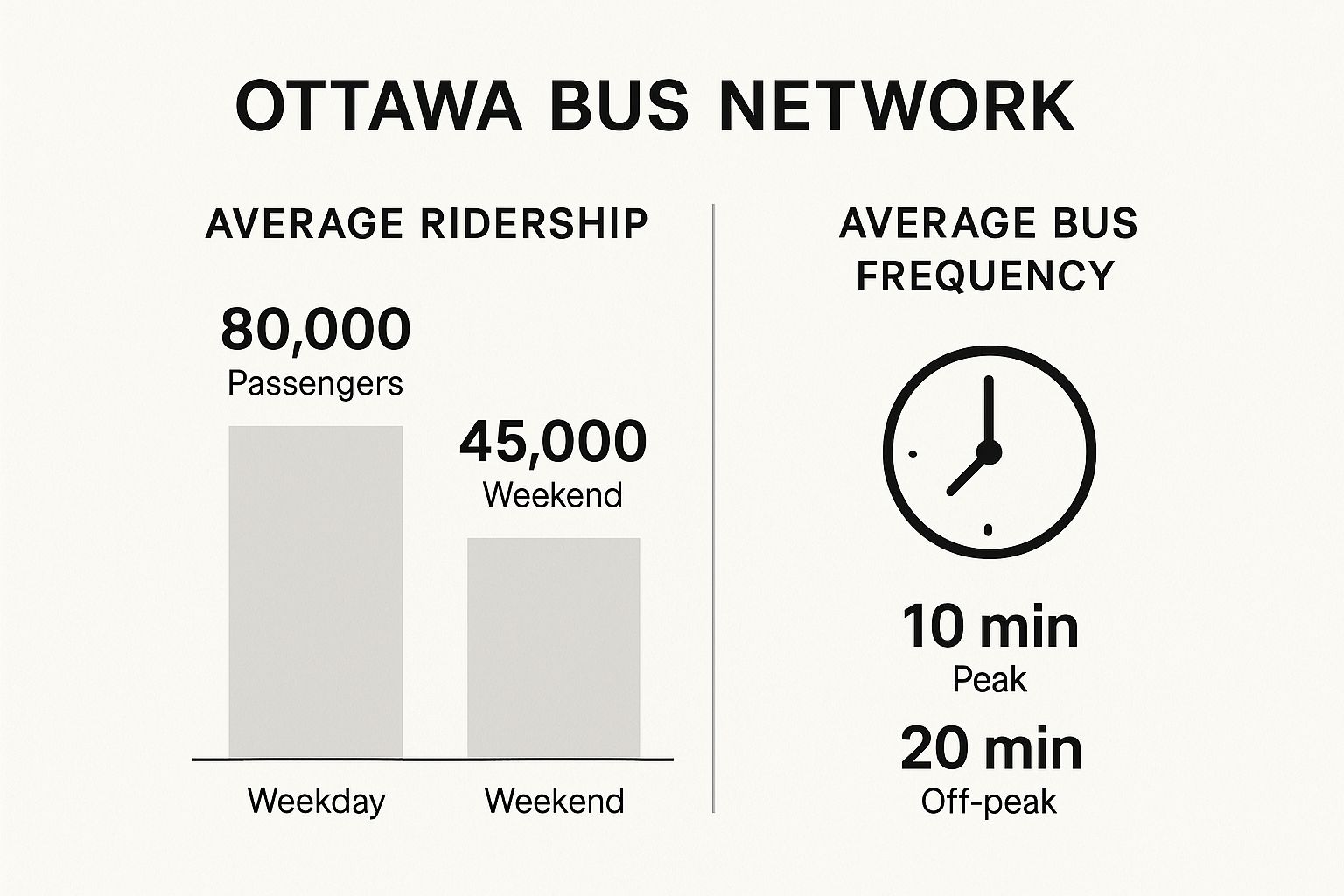
As you can see, weekday ridership is nearly double what it is on weekends. That's why service is dialled up or down to meet demand. By matching the route type to your needs, you’re essentially aligning your travel with how the system is designed to work, guaranteeing a much smoother ride.
Your Guide to Route Categories
To make smart choices, you first have to know your options. OC Transpo sorts its Ottawa bus routes into four main categories, each with a distinct job. Learning to tell them apart is like knowing when to take the 417 versus sticking to the side streets.
To simplify things, here's a quick breakdown of how these routes compare and when you'll want to use them.
Ottawa Bus Route Types at a Glance
| Route Type | Primary Function | Typical Frequency | Best For |
|---|---|---|---|
| Rapid | Long-distance travel via dedicated bus lanes (Transitway) | Very high during peak, frequent off-peak | Bypassing traffic for cross-city trips |
| Frequent | High-volume service along major city arteries | Every 15 minutes or less, all day | Reliable, everyday travel without a schedule |
| Connexion | Direct commuter service from suburbs to downtown | Peak hours only (AM/PM rush) | A one-seat ride to work from the suburbs |
| Local | Neighbourhood circulation and connections | Varies, often 30-60 minutes | Short trips to nearby shops or stations |
This table gives you a solid foundation for understanding the network's logic. Each route type is a tool, and knowing which one to use makes all the difference.
Putting It All into Practice
So, how does this knowledge actually help you day-to-day? It lets you build a smarter trip from the ground up.
Let's say you're travelling from a suburb like Barrhaven to your job downtown during rush hour. A Connexion route is your ticket to a direct, one-seat ride. But if you're heading from the Glebe to Westboro for lunch on a Saturday, a Frequent route like the 11 offers that reliable, high-frequency service you need. No need to stress about schedules.
By looking beyond just the route number and understanding its category, you can predict its behaviour. A Frequent route promises you won't wait long, while a Rapid route promises speed over local accessibility.
This strategic approach completely changes how you see the Ottawa bus routes map. Instead of a confusing web of lines, it becomes a logical system of interconnected services.
You can start combining routes for maximum efficiency—maybe take a Local bus to a nearby Transitway station, then hop on a Rapid route to finish your journey in half the time. That's the key to truly mastering your commute.
How to Master Your Commute with Trip Planners

Knowing the different types of Ottawa bus routes is a solid first step, but let's be honest—technology is what really takes the stress out of the daily commute. Digital trip planners are your secret weapon for navigating the city, giving you real-time information that a paper schedule just can't compete with.
Instead of tapping your foot and wondering if your bus is late, you can see its exact location on a map. This is a game-changer. It lets you decide if you have time to grab that last-minute coffee or if you need to hustle to the stop. Getting comfortable with one of these tools is the key to riding like a pro.
Using the Official OC Transpo Travel Planner
When you want information straight from the source, the official OC Transpo Travel Planner is your best bet. Because it’s run by the transit authority itself, its data is usually the most accurate and the first to show service alerts, surprise detours, or cancellations. Think of it as having a direct line to the control room.
The planner's interface is clean and simple, designed to get you the route options you need without any fuss.
As you can see, the core function is straightforward: plug in your start and end points, and it maps out the most efficient trip, complete with transfers and walking times. It’s a powerful tool built specifically for the OC Transpo network.
Beyond just planning a single trip, the official planner often provides crucial service updates that third-party apps might miss. This is especially important during major events, construction seasons, or bad weather when route changes happen frequently.
Sometimes, knowing why your bus is delayed can be just as helpful. For a bigger picture of what's happening on the roads, you might find our real-time Ottawa traffic map useful for anticipating slow spots along your route.
Comparing Other Popular Transit Apps
While the official planner is a solid choice, other apps bring their own unique features to the table. They all pull data directly from OC Transpo, so you can trust the schedule information is reliable. It really comes down to personal preference.
Here’s a quick look at a couple of popular alternatives:
- Google Maps: Its biggest advantage is integration. You can plan an entire journey that mixes transit, walking, and maybe even a ride-share, all in one app. It’s perfect if you're exploring a new part of the city.
- Transit App: This app is a daily commuter's dream. The moment you open it, it instantly shows you the next departure times for all the routes near your location. Its at-a-glance interface is a fan favourite for a reason.
The best app is the one that feels right for you. My advice? Give each one a try for a few days. See which interface you click with. Mastering one of these tools will make your daily travels smoother and a whole lot more predictable.
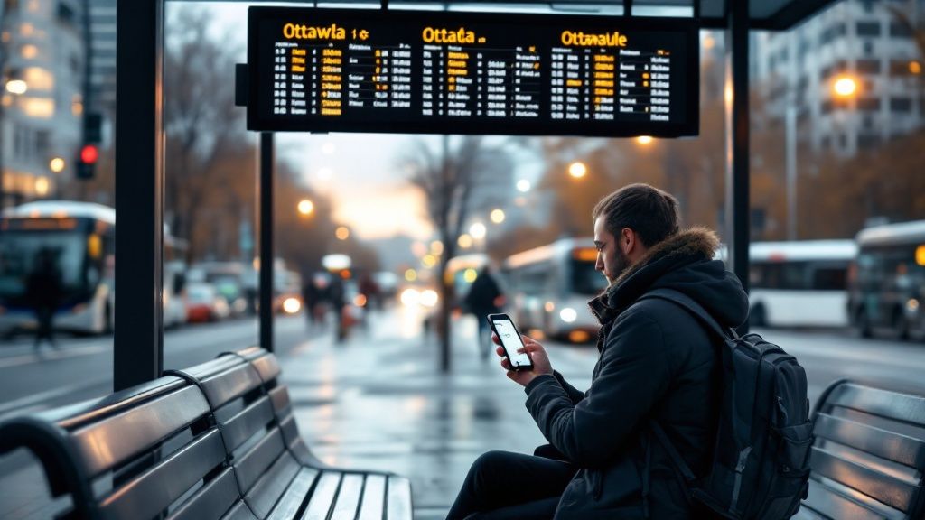
Understanding Why Your Bus Is Late and What to Do
We’ve all been there: standing at the stop, staring down the street, and wondering where on earth the bus is. The frustration of a late bus is a universal Ottawa experience, but figuring out why it's late can make the wait a little less maddening.
It’s not always a mystery. A handful of real-world factors are constantly messing with the schedule. Rush hour gridlock can turn arteries like Carling or Rideau Street into parking lots, while downtown construction projects often spring up with little warning, forcing surprise detours. And let's not forget Ottawa's wild weather—a sudden snow squall or flash of freezing rain can slow the entire network to a crawl.
The Reality of On-Time Performance
Keeping a bus perfectly on schedule, especially on the city's busiest corridors, is a huge challenge. According to OC Transpo, a bus is officially considered late if it shows up more than five minutes past its scheduled time.
So, how are they doing? Data from late 2022 to early 2023 showed that Ottawa’s 10 busiest routes were on schedule only about two-thirds of the time. For example, some of the busiest crosstown routes struggled to meet targets, with on-time performance hovering around 60%. Heavy traffic, constant detours, and the occasional mechanical hiccup all add up, painting a pretty realistic picture of the daily hurdles. You can dive deeper into the bus punctuality data in Ottawa for more insights.
How to Take Back Control of Your Commute
While you can’t single-handedly clear a traffic jam, you can arm yourself with a few strategies to minimize the stress and take back control of your day. It really makes a difference.
The key is to shift your mindset from being a passive rider who just waits for the bus to an active commuter who expects delays and plans for them. A little prep goes a long way.
Here are some simple, practical tips you can start using today:
-
Check Before You Go: Never, ever leave home without first checking a real-time tracker. Apps like the OC Transpo Travel Planner or the Transit app show you exactly where your bus is on the map. It's the single best way to manage your time. For a bird's-eye view of what's happening on the roads, check out our guide on using Ottawa's live traffic cameras.
-
Build in a Buffer: If you absolutely have to be somewhere on time, just assume the bus will be late. Add an extra 15-20 minutes to your travel time. This little cushion absorbs most minor delays and saves you a ton of anxiety.
-
Know Your Plan B: Take a few minutes to figure out a backup route. Is there another stop a few blocks away with a different line that also works? Knowing your alternative means a cancelled bus or a major delay doesn't torpedo your plans—you just walk to your backup stop and carry on.
Navigating Ottawa's Main Transit Hubs
To really get the hang of Ottawa bus routes, you first need to know the city’s transit nerve centres. These major stations are much more than just stops; they're the critical hubs where countless bus routes and O-Train lines converge.
Think of them as airports for the public transit system. They’re designed to make your transfers from one line to another as smooth and painless as possible.
Getting familiar with key locations—like Hurdman, Blair, and Tunney's Pasture—is a game-changer for any rider. These are the strategic points connecting different corners of the city, allowing someone from the east end to seamlessly switch lines and continue their journey west without missing a beat.
Knowing what each hub offers and which lines it serves is the difference between being a casual passenger and a savvy city navigator.
Key Connection Points in the Network
A few stations stand out as the most important transfer points in Ottawa’s entire network. Each one is a gateway for a specific part of the city, funnelling thousands of commuters every day between buses and trains as they travel to and from the suburbs or across the downtown core.
These hubs are also equipped with amenities to make your wait a bit more comfortable. You’ll usually find Presto machines to top up your card, clear digital signs with real-time departure info, and customer service staff ready to help out.
Major Transit Hubs and Connecting Routes
To help you visualize how the whole system connects and plan your trips better, here's a quick-reference table summarizing the main transit hubs and the key services you'll find at each one.
| Station | Connects to O-Train Line(s) | Key Connecting Bus Routes |
|---|---|---|
| Hurdman Station | Line 1 (Confederation Line) | Routes serving south Ottawa, including Alta Vista and South Keys. |
| Blair Station | Line 1 (Confederation Line) | Major hub for routes travelling to and from the east end, like Orléans. |
| Tunney's Pasture | Line 1 (Confederation Line) | Main transfer point for bus routes serving west-end communities. |
| Bayview Station | Line 1 & Line 2 (Trillium Line) | The primary interchange between Ottawa's two main O-Train lines. |
This table makes it easy to see the central role these stations play. For instance, a commuter from Orléans would grab an east-end bus to Blair Station, then hop on the O-Train to zip across downtown. Simple as that.
Understanding the function of each major station is like having a cheat sheet for the entire transit system. Instead of focusing on individual routes, you start seeing the strategic transfer points that unlock faster, more efficient travel across the city.
Once you’re comfortable with these hubs, you’ll have the confidence to build more complex journeys with ease. You'll know exactly where to go for a quick transfer, turning what could be a confusing trip into a simple, two-step process. This knowledge is fundamental to truly mastering Ottawa's public transit.
Your Top Ottawa Bus Questions Answered
Even with the perfect route planned, questions always pop up when you're actually on the move. This section tackles some of the most common things riders ask about using Ottawa's bus routes, giving you quick and simple answers for a smooth trip.
Think of it as your cheat sheet for those on-the-spot moments.
How Do I Pay My Fare on an Ottawa Bus?
You’ve got a few handy options. The most popular choice is the Presto card—just tap it on the reader when you step on the bus, and you're good to go.
You can also use O-Payment to tap your credit card or mobile wallet on the same reader for a contactless payment. If you're using cash, you'll need to pay the exact fare directly to the bus operator, but be aware that they can't give out change. Passes, like a DayPass for unlimited rides, can be easily loaded onto your Presto card.
Are OC Transpo Buses Accessible for Everyone?
Absolutely. The entire OC Transpo bus fleet is fully accessible.
Every bus has a kneeling feature that lowers the front step, plus a ramp for easy boarding with wheelchairs, scooters, and strollers. Inside, you’ll find priority seating areas clearly marked near the front. If you need the ramp, just let the operator know, and they'll be happy to help you out.
A fully accessible fleet means everyone in our community can use public transit with confidence. This commitment helps break down barriers and makes getting around the city a reliable choice for all residents.
Some riders might also qualify for financial assistance programs. We have a detailed guide that explains how to check eligibility and apply for the low-income bus pass in Ottawa.
What Is the Best Way to Get Real-Time Bus Info?
For the most up-to-the-minute information, your best bet is OC Transpo’s official website or app. They show you exactly where the buses are on a map in real time.
Many riders also swear by third-party apps like Transit or Google Maps, which pull in OC Transpo's live data. Another fantastic tool is the text service: just text your four-digit stop number to 560560, and you’ll get the next departure times sent straight to your phone.
At ncrnow, we keep you informed about everything happening in Ottawa and the National Capital Region. For the latest news and city insights, visit us at https://ncrnow.ca.