


Navigating Ottawa and the National Capital Region's busy roads requires up-to-the-minute information. Stuck in an unexpected jam on the 417 or facing a surprise closure on the Macdonald-Cartier Bridge can derail your entire day. This is where live traffic cameras become an indispensable tool for commuters, delivery drivers, and anyone needing to travel efficiently. They provide a real-time, visual confirmation of road conditions that static maps and GPS alerts often miss, allowing you to see congestion, accidents, or weather-related hazards with your own eyes before you even leave.
This guide is designed to cut through the clutter and direct you to the most reliable and user-friendly sources for traffic cameras. We've compiled a comprehensive list of the best official government websites, third-party platforms, and mobile applications. Each entry includes a practical analysis of its strengths and weaknesses, screenshots for a quick preview, and direct links to get you started immediately. Whether you're planning your daily commute across the Ottawa River, managing a fleet of commercial vehicles, or just trying to avoid a bottleneck on your way to an appointment, this resource will help you find the perfect tool to see the road ahead clearly and make smarter travel decisions.
1. BC Traffic Cams
For those planning a trip out west or needing to navigate British Columbia's extensive road network, BC Traffic Cams is a valuable, no-frills tool. This website provides direct, free access to a comprehensive collection of live traffic cameras across the province, from the bustling streets of the Lower Mainland to the winding mountain passes of the Okanagan. Its primary strength lies in its simplicity and singular focus on delivering real-time road imagery without requiring registration or payment.
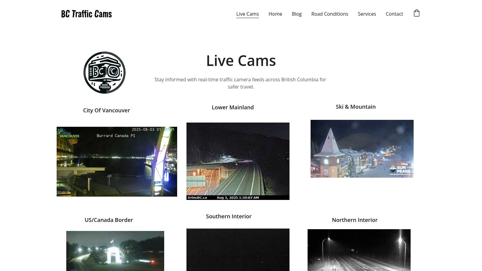
The user experience is straightforward: a map-based interface allows you to quickly select specific highways or regions to view current conditions. This makes it an excellent resource for checking weather on the Coquihalla before a long drive or assessing congestion on the Sea-to-Sky Highway. While its coverage is geographically limited to B.C., its mobile-friendly design ensures you can get a quick visual update from anywhere. This focus on a single province ensures the information is detailed and relevant for anyone travelling within its borders, a crucial factor for those considering a move or navigating the unique challenges of life in Canada.
Key Considerations
- Best Use Case: Ideal for pre-trip planning for journeys within British Columbia, especially for checking weather and road conditions on major highways and mountain passes.
- Limitations: The service is entirely dependent on the operational status of government-owned cameras. A camera being offline means no image is available.
- Access: Completely free with no signup needed.
Website: https://www.bctrafficcams.ca
2. Québec 511 Traffic Cameras
For commuters and travellers crossing into Gatineau or navigating other parts of Québec, the official Québec 511 platform is an essential government-run resource. It provides comprehensive, free access to a vast network of live traffic cameras across the province, presented in a clean, mobile-friendly interface. A key advantage for residents of the National Capital Region is its full bilingual support, offering all features in both English and French, which makes it highly accessible. The service’s strength is its direct integration with official provincial road data.
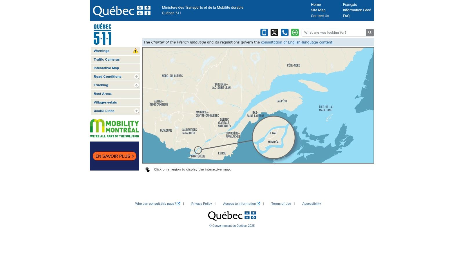
The user experience is built around an interactive map, allowing you to easily pinpoint specific routes like Autoroute 50 or key bridges connecting Ottawa and Gatineau. This makes it incredibly practical for checking cross-river traffic before starting your commute or verifying road conditions during adverse weather. While its scope is limited to Québec, its focused and official data feed ensures accuracy. This official backing means the information is reliable and up-to-date, a crucial factor for daily commuters and long-distance travellers alike.
Key Considerations
- Best Use Case: Excellent for daily commuters between Ottawa and Gatineau and for planning trips anywhere within Québec. The bilingual interface is a major plus.
- Limitations: Coverage is strictly within Québec's borders. Like other government services, camera availability depends on their operational status and can be subject to downtime.
- Access: Completely free to use, with no registration or account required.
Website: https://www.quebec511.info
3. Ontario 511
For commuters and travellers across Ontario, the official Ontario 511 service is a comprehensive resource that goes beyond basic imagery. This platform provides free, direct access to a network of live traffic cameras covering major highways. Its key differentiator is its integration with other critical road data, presenting not just a visual but a complete operational picture of the provincial highway system. No registration or payment is required, making it an accessible first stop for any road trip.
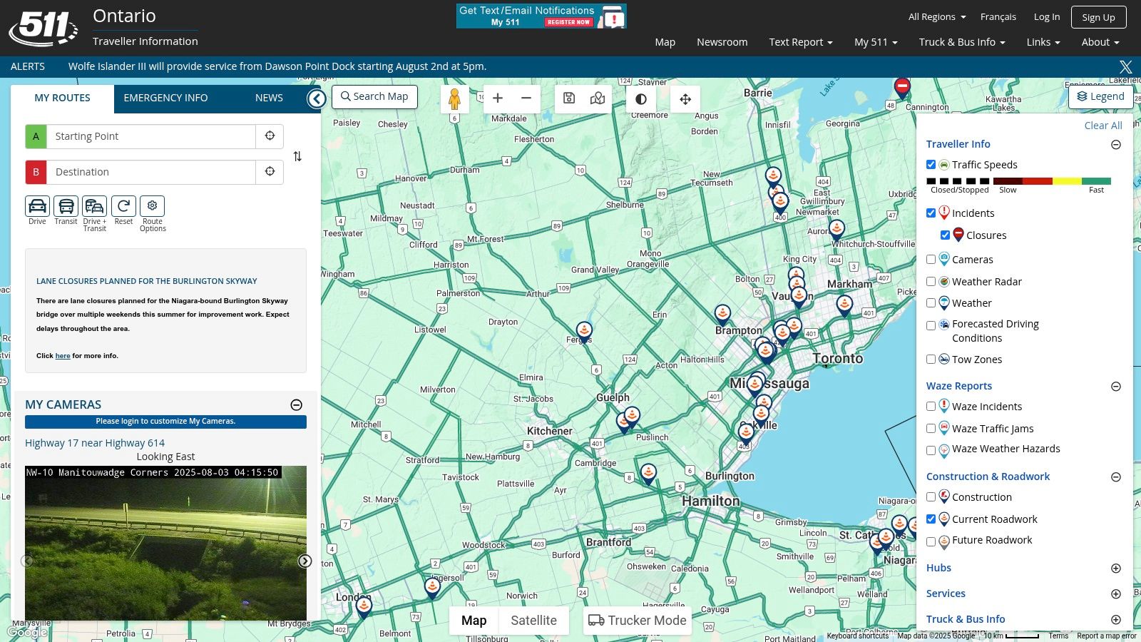
The user interface presents a map overlay showing camera locations, construction, incidents, and even snowplow tracking in the winter. This makes it an invaluable tool for planning routes around delays or preparing for weather-related challenges on corridors like the 401 or 417. For those seeking a more advanced view, the platform has previously offered features like KML file integration with GIS software. While its coverage is limited to provincially managed highways, the depth of information provided is a significant asset for any driver in Ontario, a crucial detail for navigating the region as seen on any Ottawa traffic map.
Key Considerations
- Best Use Case: Excellent for daily commuters on provincial highways and for planning long-distance trips across Ontario, combining camera views with closure and incident reports.
- Limitations: Camera feeds are exclusive to provincial highways, not municipal roads. Advanced features and integrations may change over time.
- Access: Completely free to use with no signup necessary.
Website: https://www.ontario.ca/511
4. Traffic Cameras: Live (App)
For commuters who prefer a dedicated application on their phone, Traffic Cameras: Live offers a consolidated mobile solution. This app aggregates live traffic cameras from various sources worldwide into a single, user-friendly interface. Its primary advantage is its global reach, providing access to feeds not only within Ottawa and the National Capital Region but across Canada and beyond. This makes it a versatile tool for both daily commutes and long-distance travel planning, all without leaving the app.
The experience is streamlined for on-the-go use, allowing users to quickly browse nearby cameras or search specific locations. While the app is free to download, it’s important to note that some advanced features may be locked behind in-app purchases. Its real strength lies in convenience, centralizing thousands of camera feeds that would otherwise require visiting multiple websites. For Ottawa drivers, this means having a powerful pocket resource to visually verify traffic flow on key routes like the Queensway or bridges to Gatineau before getting behind the wheel.
Key Considerations
- Best Use Case: Ideal for mobile users who want a single app to check traffic cameras in various cities, including Ottawa, without juggling different websites.
- Limitations: The app's functionality is entirely dependent on the availability and operational status of third-party camera feeds. Some features require payment.
- Access: Free to download on the App Store, with optional in-app purchases available.
Website: https://apps.apple.com/app/traffic-cameras-live/id123456789
5. Traffic Cam+ (App)
For travellers whose routes extend beyond the National Capital Region, Traffic Cam+ offers a global perspective on road conditions directly from your smartphone. This app aggregates a large database of live traffic cameras from around the world, including extensive coverage in Canadian cities. Its primary advantage is its sheer volume of sources, making it a versatile tool for planning both local commutes and international road trips without switching between different regional platforms.
The app's interface is designed for mobile use, supporting both portrait and landscape modes for easy viewing. You can browse camera feeds on a map or search for specific locations, making it simple to check your route before heading out. While a free version provides core functionality, a paid upgrade is required to unlock unlimited camera views and remove ads. Its broad scope means it’s an excellent all-in-one solution, though it is dependent on third-party camera availability, which can occasionally be inconsistent.
Key Considerations
- Best Use Case: Ideal for users who frequently travel to different cities or countries and want a single app for checking traffic cameras globally.
- Limitations: The free version has limitations on views and includes ads. The functionality of individual cameras is dependent on external providers, so some may be offline.
- Access: A free version is available on the App Store; a full version requires a one-time purchase.
Website: https://apps.apple.com/app/traffic-cam/id987654321
6. WeatherBug Traffic Cameras
For commuters who understand that weather and traffic are intrinsically linked, WeatherBug offers a powerful, integrated solution. While primarily known as a weather forecasting service, it cleverly combines this data with live traffic cameras to provide a holistic view of your route. This platform is particularly useful for assessing not just congestion but also how conditions like rain, snow, or fog are actively impacting visibility and road safety in real time.
The user interface is modern and intuitive, displaying camera feeds directly on a map alongside weather overlays. This integration is WeatherBug's key differentiator, allowing you to see if a slowdown is due to an accident or a sudden downpour without switching between apps. It’s an excellent tool for daily commute planning, especially during the volatile weather seasons common in the National Capital Region. Planning your drive to one of the many upcoming events in Ottawa becomes much more predictable when you can see both the traffic and the weather in one place.
Key Considerations
- Best Use Case: Excellent for daily commuters who want to see the combined impact of weather and traffic on their route in a single, easy-to-use interface.
- Limitations: Camera availability is not as comprehensive as dedicated government traffic sites and is entirely dependent on sourcing third-party feeds. Coverage can be inconsistent outside of major metropolitan areas.
- Access: Completely free on both its website and mobile apps, with no registration required for core features.
Website: https://www.weatherbug.com/traffic
7. everyWebcam.com
While many resources focus solely on government-run cameras, everyWebcam.com operates as a vast public directory, aggregating webcams across Canada. This platform stands out by including not just official live traffic cameras but also scenic, private, and business-hosted webcams, offering a much broader visual scope of a region. For users in Ottawa, this means you can check a major intersection on the 417 and then pivot to a view of Parliament Hill or a local ski resort, all from one interface. Its strength lies in this comprehensive collection of publicly available feeds.
The website's user experience is simple, presenting cameras on a map and in a list format that can be easily filtered. A useful feature is the ability to filter by theme (like "traffic" or "city"), which helps users quickly find the most relevant feeds. While it's an excellent tool for discovery and getting a wider sense of conditions, its reliance on a vast network of third-party cameras means that some links may occasionally be inactive or offline, a common issue for aggregator sites.
Key Considerations
- Best Use Case: Discovering a wide variety of public webcams in a specific area, including but not limited to traffic, for a broader contextual view.
- Limitations: The operational status of cameras is dependent on external third-party owners, so some may be temporarily or permanently offline.
- Access: Completely free to use with no registration required.
Website: https://www.everywebcam.com/canada
8. Trucker Guide Traffic Cameras
While its name suggests a niche audience, Trucker Guide Traffic Cameras is a surprisingly robust resource for any driver navigating Ontario's busiest corridors. The site offers a straightforward, list-based portal to live traffic cameras across the province, with a strong focus on the Greater Toronto Area and other major hubs. Its key advantage is its directness; it aggregates official Ministry of Transportation (MTO) camera feeds into a single, easily scannable page, removing the need to navigate more complex government websites.
The user experience is simple and utilitarian, designed for quick checks rather than deep exploration. You scroll through a list of locations, click the link, and get an immediate visual of the current road conditions. This makes it highly effective for a last-minute check of Highway 401 congestion before heading out of Ottawa towards Toronto. Although its interface is less modern than map-based alternatives and its coverage is confined to Ontario, its laser focus on providing direct camera access makes it a valuable, no-nonsense tool.
Key Considerations
- Best Use Case: Excellent for quick, specific checks on major Ontario highways like the 401, 417, and QEW, particularly for commuters or those planning inter-city travel.
- Limitations: The platform is entirely dependent on the availability and functionality of government-provided camera feeds. Its geographic scope is limited to Ontario.
- Access: Completely free to use without any need for registration or login.
Website: https://www.truckerguide.ca/traffic-cameras
9. DriveBC
For travellers heading to or through British Columbia, DriveBC is the official and authoritative source for road information. As a government-run service, it offers an extensive and reliable network of live traffic cameras spanning the entire province, from Vancouver Island to the Rocky Mountains. The platform's primary value lies in its accuracy and comprehensive coverage, providing real-time updates on road conditions, construction, and major incidents directly from the source. It’s an essential tool for anyone planning a long-haul trip or commuting on B.C.’s diverse highways.
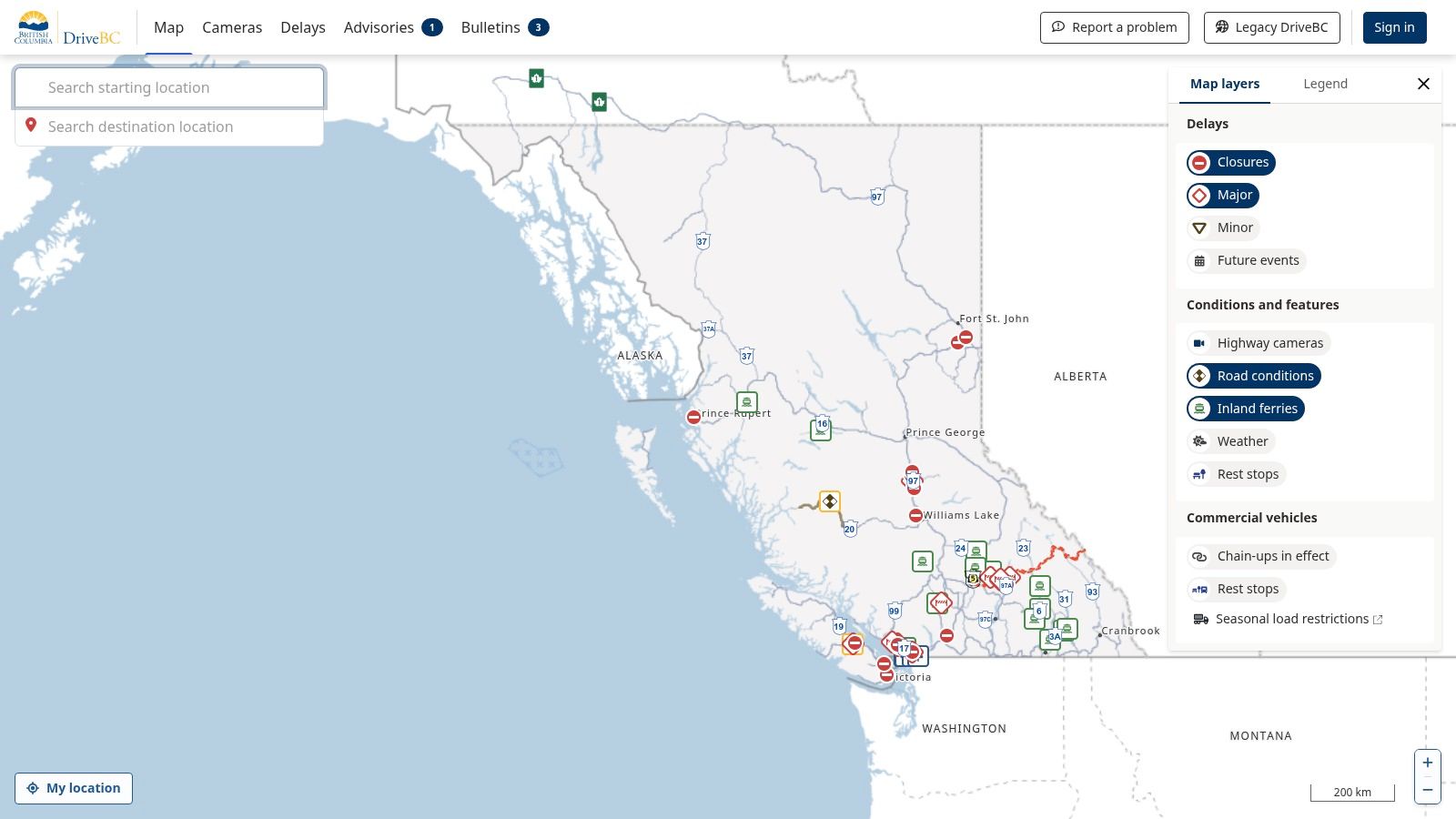
The website features a map-based interface that allows users to view camera feeds, check travel advisories, and even see current weather conditions. This integration makes it a one-stop shop for trip planning, particularly for routes that involve significant elevation changes or remote areas. Its mobile-friendly design ensures that this critical information is accessible on the go. While its scope is confined to B.C., the depth of its data is unparalleled for the region, making it an indispensable resource for ensuring a safe journey.
Key Considerations
- Best Use Case: Planning long-distance travel within British Columbia, checking mountain pass conditions, and getting official updates on road closures or incidents.
- Limitations: Coverage is geographically restricted to British Columbia. Camera functionality is dependent on government maintenance and operational status.
- Access: Completely free to use without any need for an account or registration.
Website: https://drivebc.ca
10. 511 Alberta
For travellers heading west, 511 Alberta is the official and authoritative source for road conditions across the province. This platform offers an extensive, real-time look at Alberta’s highway network through a vast array of live traffic cameras. It serves as an essential tool for anyone planning a drive to or through the province, whether it's for monitoring construction delays around Calgary or checking for snow on the route to Banff. The service is free, requires no signup, and provides a dependable one-stop shop for official road information.
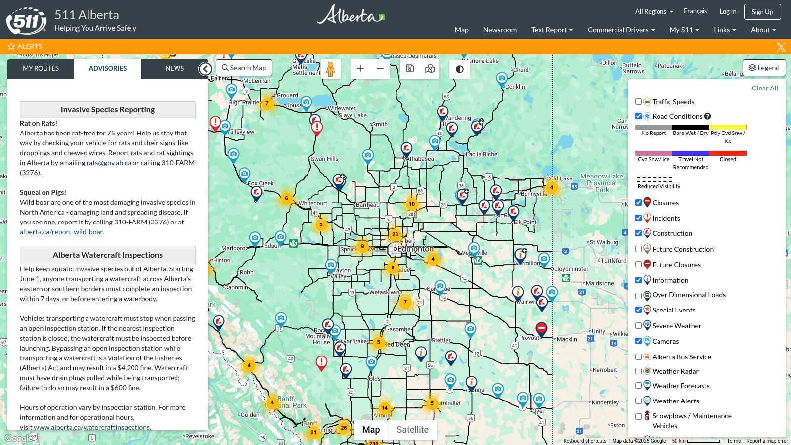
The user-friendly, map-based interface allows you to filter by specific routes, incidents, and camera locations, making it easy to get a visual confirmation of road status. While its utility is confined to Alberta's borders, its comprehensive coverage within the province is its greatest asset. This makes it invaluable for long-haul drivers, tourists, and anyone needing to navigate the often-unpredictable weather conditions that can impact major routes like the Queen Elizabeth II Highway. It's an official government source, ensuring the information is reliable and up-to-date.
Key Considerations
- Best Use Case: Planning long-distance travel through Alberta, checking for incidents, and monitoring weather conditions on key corridors like the Trans-Canada Highway.
- Limitations: Coverage is strictly limited to Alberta. The system relies on functioning government cameras, so a downed camera results in a blind spot.
- Access: Completely free to use without any need for registration.
Website: https://511.alberta.ca
11. Manitoba 511
For those travelling west from Ontario or navigating the Prairies, Manitoba 511 is the official and most reliable source for road conditions. This government-run platform provides a comprehensive suite of tools, including a network of live traffic cameras, real-time incident reports, and construction updates. Its primary value is offering a one-stop-shop for all critical travel information within the province, directly from the source. The interface is built around an interactive map, making it easy to plan a route and visually verify conditions along the way.
The mobile-friendly design ensures that drivers can access crucial updates on the go, a key feature for long-haul journeys across the expansive Manitoban landscape. While the service is geographically focused, its detailed coverage of major routes like the Trans-Canada Highway is invaluable for anyone passing through. It effectively centralizes essential data, removing the need to consult multiple sources for weather, closures, and traffic flow, making it a trustworthy companion for Prairie travel.
Key Considerations
- Best Use Case: Planning and monitoring trips across Manitoba, particularly for checking conditions on major inter-provincial highways and rural routes.
- Limitations: Coverage is strictly limited to Manitoba. The availability of imagery is entirely dependent on the operational status of government-owned cameras.
- Access: Completely free to use with no registration required.
Website: https://www.manitoba511.ca
12. Saskatchewan Highway Hotline
For anyone travelling through Canada's prairie heartland, the Saskatchewan Highway Hotline is an essential resource. This official government-run service provides a comprehensive overview of road conditions, construction, and incidents across the province. A key feature for modern travellers is its network of live traffic cameras, offering real-time visual confirmation of what lies ahead on major routes. Its singular focus on Saskatchewan ensures the information is reliable and highly specific, which is critical for navigating the vast road system.
The user interface is functional and map-centric, allowing you to easily pinpoint specific highways or regions to check conditions. This is particularly valuable for planning long-haul trips, verifying weather reports, or understanding the impact of sudden prairie storms on travel. While its scope is geographically limited, the platform's dedication to providing accurate, up-to-the-minute information for Saskatchewan drivers makes it a trustworthy tool. Access is direct and free, with no registration needed to view the camera feeds or road reports.
Key Considerations
- Best Use Case: Planning travel within or through Saskatchewan, especially for checking road and weather conditions on long, open stretches of highway.
- Limitations: Coverage is exclusive to Saskatchewan. The availability of visual information is entirely dependent on the operational status of the government's camera network.
- Access: Completely free to use without any need for an account or signup.
Website: https://highwayhotline.sk.ca
Live Traffic Cameras: Feature Comparison of 12 Resources
| Service | Core Features/Coverage | User Experience / Quality ★★★★☆ | Value Proposition 💰 | Target Audience 👥 | Unique Selling Points ✨ | Price 💰 |
|---|---|---|---|---|---|---|
| BC Traffic Cams | BC-wide real-time cameras | Mobile-friendly, easy navigation | Free access, no registration | Travelers in BC | Simple, focused BC coverage | Free |
| Québec 511 Traffic Cameras | Quebec-wide live feeds, bilingual | Mobile-friendly, user-friendly | Free, official government source | Quebec residents & travelers | Bilingual interface (Eng/Fre) | Free |
| Ontario 511 | Ontario highways, incident reports | Map-based, data-rich interface | Free, official government source | Ontario commuters & travelers | Snowplow tracking, official data | Free |
| Traffic Cameras: Live (App) | Global coverage including Canada | Intuitive mobile UI | Free download, optional purchases | Commuters worldwide | Aggregates global feeds in one app | Free (+IAP) |
| Traffic Cam+ (App) | Large global camera database | Dynamic display, map view | Free basic, paid full version | Global travelers and drivers | Extensive camera selection | Free (+paid) |
| WeatherBug Traffic Cameras | Traffic + weather integration | Multi-platform, intuitive map | Free, no registration | Weather-conscious drivers | Real-time weather + traffic data | Free |
| everyWebcam.com | Aggregates various Canadian webcams | Filter by theme/quality | Free, vast webcam directory | General public, curious users | Broader than just traffic cams | Free |
| Trucker Guide Traffic Cameras | Ontario-focused MTO camera feeds | Simple list-based design | Free access, no registration | Truckers & all Ontario drivers | Quick access to MTO feeds | Free |
| DriveBC | Official BC portal, real-time traffic | Mobile-friendly, authoritative | Free, official government data | BC commuters & travelers | Government-backed, all-in-one BC info | Free |
| 511 Alberta | Alberta-wide traffic & incident updates | User-friendly, map interface | Free, official government source | Alberta travelers & commuters | Official Alberta data source | Free |
| Manitoba 511 | Manitoba traffic cams & incident reports | Mobile-friendly, map-based | Free, official provincial info | Manitoba travelers | Centralized official source | Free |
| Saskatchewan Highway Hotline | Saskatchewan road conditions & cameras | Functional, map-centric design | Free, official government source | Saskatchewan travelers | Comprehensive provincial data | Free |
Final Thoughts
Navigating the roads requires more than just a good sense of direction; it demands real-time, accurate information. As we've explored, the landscape of live traffic cameras offers a powerful toolkit for any commuter, traveller, or logistics planner looking to outsmart congestion, anticipate delays, and ensure a safer journey. From official government portals like Québec 511 and Ontario 511 to versatile third-party applications, the right resource is available to fit your specific needs.
The key takeaway is that no single tool is universally perfect. The most effective strategy often involves a multi-tool approach. A dedicated local app might be your daily go-to for its user-friendly interface, while a comprehensive government site like Ontario 511 becomes invaluable for planning longer trips or checking on specific highway conditions outside the city centre. The power lies in understanding the strengths and limitations of each resource and integrating them into a personalised traffic monitoring system.
Choosing Your Go-To Traffic Tool
When selecting the best tool for your routine, consider these critical factors:
- Coverage and Location: Does the tool provide robust camera coverage for your specific routes? A driver who frequently crosses between Ottawa and Gatineau will prioritise a tool with seamless integration of both Ontario and Québec cameras, such as Québec 511 or a well-designed third-party app.
- Update Frequency: How current is the information? For daily commuting during peak hours, a camera feed that refreshes frequently is far more valuable than one that updates every five minutes. Official sources generally offer the most reliable and frequent updates.
- User Interface and Accessibility: How easy is it to find what you need, especially when you're about to head out the door? A clean map interface, saved favourite cameras, and quick-loading images are hallmarks of a superior user experience. Test a few apps to see which one feels most intuitive to you.
- Additional Features: Do you need more than just a visual? Resources like WeatherBug that integrate weather forecasts with traffic visuals, or the 511 services that provide road closure details, offer a more holistic view of your potential travel conditions.
Ultimately, leveraging live traffic cameras transforms you from a reactive driver, stuck in unforeseen traffic, to a proactive navigator, making informed decisions before you even turn the key. By bookmarking your preferred websites and keeping a trusted app on your home screen, you can build a simple yet powerful habit of checking conditions ahead of time. This small step can save you countless hours of frustration, reduce fuel consumption, and contribute to a safer, more predictable commute through our bustling capital region.
For a consolidated view of real-time conditions, including traffic updates, news, and events impacting your drive across the National Capital Region, check out ncrnow. We curate the essential information you need, all in one place, helping you stay ahead of the curve every day. Visit ncrnow to streamline your local information intake.